

Company Overview
Summit Petroleum is an independent oil and gas operator focused on developing high-quality unconventional resources in the Permian Basin. The company’s current Howard County permitting program demonstrates a disciplined manufacturing approach to shale development, characterized by centralized multi-well pads, phased permitting, and long-term inventory management designed to maximize capital efficiency and reservoir recovery.

A Manufacturing Development Program, Not a Single Drilling Campaign
While the project consists of only 16 permitted wells, the permit data tells a much larger story.
Rather than permitting isolated wells, Summit Petroleum appears to have designed a full-section development program centered on the Mary Lou lease. The permits are organized into multiple surface pads, licensed in batches, and drilled sequentially—an approach commonly used by large Permian operators executing multi-year development plans.
Project Snapshot
| Metric | Value |
|---|---|
| Total Permits | 16 |
| Surface Pads (50 m clustering) | 4 |
| Largest Pad | 7 wells |
| Primary Lease | Mary Lou |
| County | Howard County |
| Basin | Midland Basin (Permian) |
| Drilling Type | Horizontal |
| Primary Commodity | Oil |
Wells per Surface Pad
Summit Petroleum wells by surface pad
Multi-well pad distribution based on 50 m transitive clustering.02468PAD-001PAD-002PAD-003PAD-004
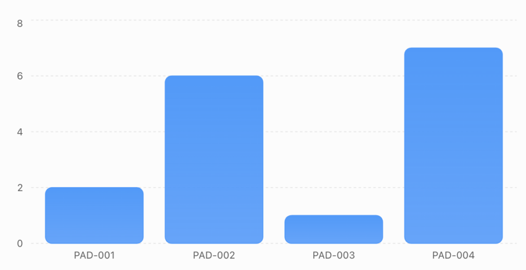
The distribution shows a classic factory-style development pattern, with two large production pads accounting for the majority of planned wells.
Surface Development Pattern
The permits reveal a highly organized drilling program.
Surface Characteristics
| Attribute | Observation |
|---|---|
| County | Howard County |
| Basin | Midland Basin |
| Primary Lease | Mary Lou |
| Surface Pads | 4 |
| Largest Pad | 7 wells |
| Permits Licensed Together | Yes |
| Contractor Assigned | Precision 581 and Precision 626 (initial phase) |
Nearly 88% of all wells belong to the Mary Lou lease, indicating Summit is developing one large asset rather than multiple disconnected prospects.
The application numbers, licence dates, and pad assignments are closely aligned, suggesting permits were submitted as coordinated drilling packages rather than individual well applications.
A Multi-Year Full-Section Development
One of the strongest indicators of a manufacturing project is how permits are grouped.
The permit data indicates Summit is developing the acreage in phases:
Phase 1
- Initial permits
- First pads licensed
- Precision rigs mobilized
- Drilling begins
Phase 2
- Additional pads licensed
- Future inventory established
- Contractors not yet assigned
Instead of continuously applying for one permit at a time, Summit appears to have secured much of the drilling inventory up front, reducing regulatory risk and providing flexibility for future capital allocation.
Evidence of a Stacked Reservoir Strategy
Projected depths vary across the development program.
Pad Minimum Depth Maximum Depth Average Depth PAD-001 7,240 ft 7,830 ft 7,535 ft PAD-002 7,100 ft 8,600 ft 8,117 ft PAD-003 9,200 ft 9,200 ft 9,200 ft PAD-004 7,100 ft 9,200 ft 8,157 ft
Although permit data does not identify the target formation, the approximately 2,100-foot range in projected depths is consistent with development across multiple landing intervals or benches. In Howard County, operators commonly exploit stacked reservoirs within the Spraberry and Wolfcamp system, making a multi-bench strategy plausible. Because the permit file does not specify the target formation, this should be viewed as a well-supported interpretation rather than a confirmed fact.
Drilling Activity Suggests a Long-Term Program
Current activity indicates Summit is still in the early stages of execution.
Metric Value Wells Drilled 2 Wells Awaiting Drilling 14 Drilling Contractors Precision 581, Precision 626
Only two wells have activity dates, while fourteen remain permitted but undrilled. This pattern is typical of operators that secure a large inventory of approved locations and execute drilling over multiple years rather than completing all wells immediately.
Why This Matters
For suppliers and service companies, the value of this project extends beyond the first two drilled wells.
The permit inventory suggests future demand for:
- Drilling contractors
- Directional drilling
- Completions services
- Hydraulic fracturing
- Artificial lift
- Production equipment
- Tank batteries
- Water infrastructure
- Midstream gathering
- Surface facilities
As each pad progresses from permitting to construction and drilling, additional service opportunities are likely to emerge.
Market Intelligence Perspective
The permit data portrays Summit Petroleum as an operator following the same disciplined development model used by larger Permian producers. Multiple surface pads, batch permitting, phased rig deployment, and a large inventory of undrilled locations point to a multi-year, full-section development program rather than a short-lived drilling campaign.
While the available permit data does not conclusively prove development of multiple benches, the depth variation, common surface locations, and coordinated permitting support the interpretation that Summit is positioning the acreage for long-term exploitation of a stacked reservoir system. As additional wells are licensed and drilled, tracking permit batches, pad construction, and contractor assignments will provide valuable insight into the pace and direction of the company’s development strategy.


Author: phinds