
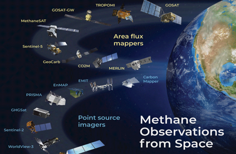
At least two dozen high-resolution satellites are expected to be in orbit by the end of this year, quietly tracking emissions that’s invisible to the naked eye. Their sensors are able to detect the natural gas component from pipelines, unlit flares, storage tanks and compressor stations around the world.
Commercial and state interests are driving an acceleration in satellite launches at a time when fossil fuel companies face investor pressure to quantify and slash their emissions, and governments intent on meeting global climate targets seek to benchmark progress. The satellite missions include public and private efforts and are poised to deliver climate transparency on a scale never before seen.
“There’s been strong demand for facility-level information on emissions because it’s directly actionable,’’ said Daniel Varon, a postdoctoral researcher studying atmospheric composition and satellite remote sensing at Harvard University. Varon and peers published an overview of how high- and low-resolution satellites are used to track methane last year.
So far this year, at least three high-resolution satellites have launched, and four more are expected to enter orbit before 2024. Much of the demand for the data is coming from oil and gas operators themselves, who are increasingly using the systems to identify leaks along thousands of miles of pipeline or remote facilities. GHGSat Inc., a private company that has worked with operators, including Royal Dutch Shell Plc, Chevron Corp. and TotalEnergies SE to detect leaks, made about a million facility measurements last year and is on track to double that in 2023.
How methane is detected from space
Satellites observe concentrations of methane from space by analyzing the way sunlight reflects off the Earth. As light passes through a cloud of the gas, its intensity is weakened on certain wavelengths. Methane absorbs light in the short-wave infrared portion of the electromagnetic spectrum.
Firms, including GHGSat and Carbon Mapper, a non-profit working with partners including Planet Labs PBC, are launching satellites designed specifically to detect methane. But much of the new high-resolution imagery is the result of data processing innovations that leverage observations from public satellites that weren’t explicitly built to observe the greenhouse gas yet have spectral bands that include the short-wave infrared.
This year could see a wave of new reports on operator leaks, as new orbitals increase the coverage and frequency of observations. For operators unable to halt their emissions, that may mean a loss of credibility, fees or trouble insuring future projects.
Energy News


Author: phinds