
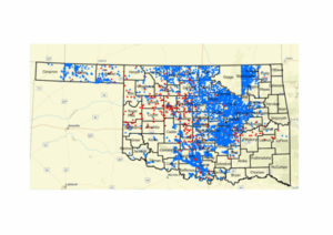
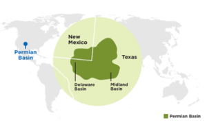
In the aerial surveys performed in the Permian Basin, 5,361 pieces of equipment were identified on 1450 facilities over 250 square miles using Gas Mapping LiDAR™ (GML) remote sensor technology. Out of these 5000+ pieces of observed equipment, 6.0% were identified as emitters on the first pass.
For this study, emitters are defined as equipment observed to be releasing methane into the atmosphere, irrespective of whether that equipment is exhibited as routine or unintended emissions.
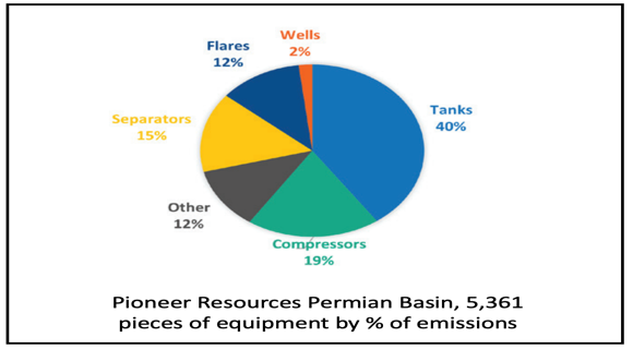
The aggregate results of the GML survey for all surveyed areas, grouped by equipment type, show that tanks resulted in the most significant volume (40%) of methane emissions released from the target areas. This result is consistent with findings from previous aerial studies, such as those conducted by helicopter flyover with Forward Looking Infrared (FLIR) Cameras which found most detectable emissions were from tanks.

The survey also found that compressors were responsible for 19% of total detectable emissions, and more than 25% of the compressors in the survey area showed detectable methane emissions.
Equipment on or near a separator was also identified as a significant source of emissions, contributing 15% of all detectable emissions. Note that only a small fraction of the separators (fewer than 5%) resulted in detectable emissions.
Flares contributed 12% of emissions, and approximately 13% of the flares identified had detectable methane emissions.
Equipment not including tanks, such as buried pipe and unknown or unclassified assets, also represented a considerable source of detected methane emissions (around 12%). Wellheads, on the other hand, were found to be a minor source of overall detected emissions, contributing only 2% of all detected emissions.
Energy News


Oil & Gas Permits

Author: phinds