
Martin County ranks #3 in the state for BOE produced in the most recent month (Jul 2022). The information below is the summary of oil and gas data that goes back to 1993 and contains information on the 11,347 wells that have been drilled from Jan 1993 to Jul 2022.
Martin County Wells Drilled
- Martin County, TX ranks #2 in the Mid Continent (TX, OK,NM,LA) for wells drilled in 2022 with 749 wells drilled up to Oct 2022.
- Martin County, TX ranks #1 in the Mid Continent (TX, OK,NM,LA) for wells drilled 303 Q1 2023.
Martin County Drilling Rigs
- Martin County, TX ranks #3 in the Mid Continent (TX, OK,NM,LA) for average drilling rigs operating per month in 2022 with 35 rigs.
- Martin County, TX ranks #3 in the Mid Continent (TX, OK,NM,LA) for average drilling rigs operating per month in 2023 with 43 rigs.
Martin County is a county in the U.S. state of Texas. As of the 2010 census, its population was 5,237. Its county seat is Stanton. The county was created in 1876 and organized in 1884. It is named for Wylie Martin, an early settler. Until November 2018, Martin County was one of six entirely dry counties in Texas.
The Midland Basin is located in the Permian Basin, which spans western Texas and eastern New Mexico, represents the most prolific hydrocarbon production region in the United States. They accounted for about 30% of U.S. crude oil production and 14% of U.S. natural gas production (measured as gross withdrawals) in 2020. Technology innovations, such as longer lateral wells and multi-well pad drilling, has helped reduce costs and increase productivity in developing oil and natural gas resources in the Permian Basin.
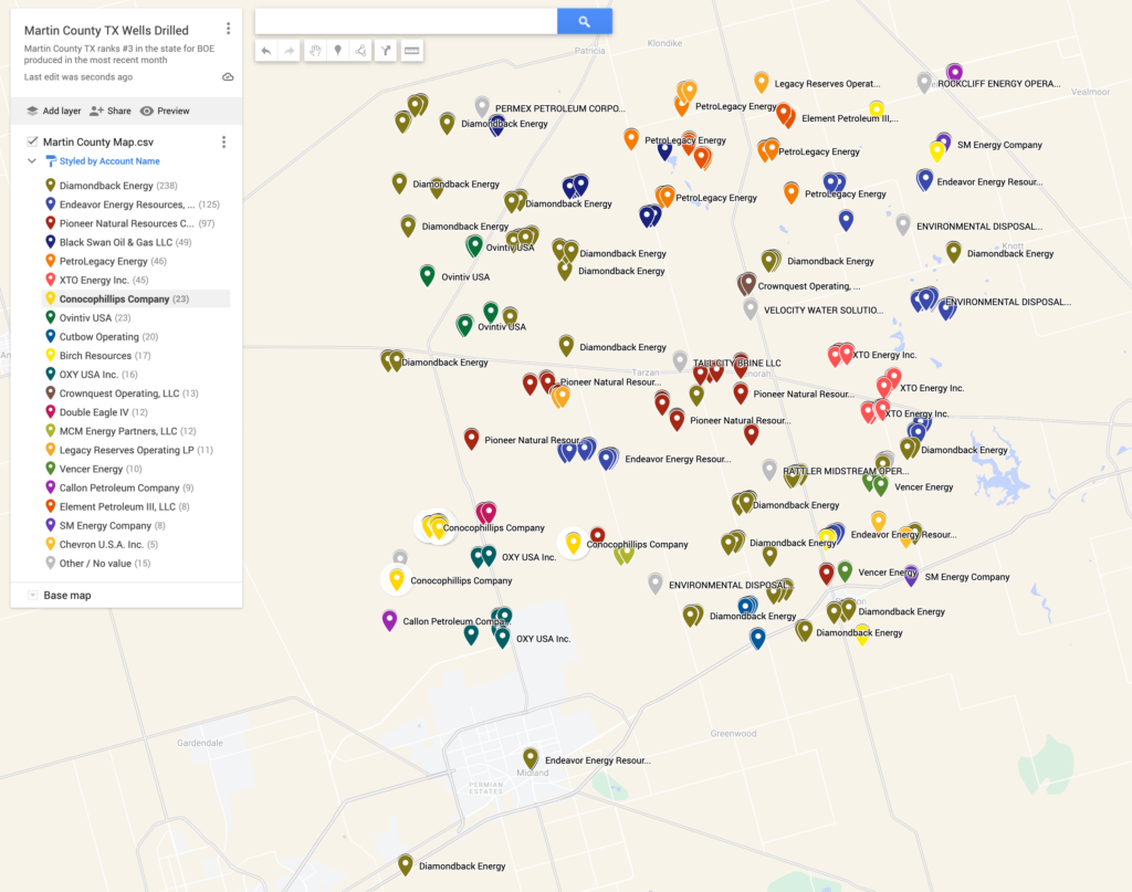
Wells Drilled by Operator in Martin County 2022
Oil & Gas Permit Download
Martin County Wells Drilled 2022 & 2023
Martin County Drilling Rigs 2022 & 2023
Martin County Wells Drilled 2022 Map
Martin County Gas Plants
Gas Plant & Air Permits Download Details
Air Permits for Oil Gas Facilities Approved 2023
Martin Count Gas Plant Map
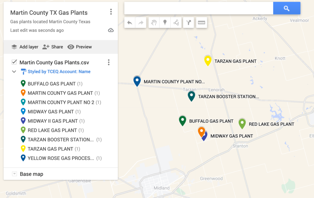
Martin County Gas Plant Locations
Account Name Plant Name Physical Location Brazos Midstream Operating SUNDANCE PLANT 2483 COUNTY ROAD C2901 DCP Midstream MARTIN COUNTY PLANT NO 2 21 MILES NNW OF MIDLAND OFF HWY 349 DCP Midstream MIDWAY GAS PLANT FROM INTX OF RR 1208 AND E HWY 80 11 OF MIDLAND GO 4.7 MI N ON RR 1208 TO RR 1212 TURN L GO N 2.7 MI THEN W 1.5 MI ON RR 1212 TO FORK BEAR L ONTO GRAVEL ACCESS RD GO 0.5 MI TO BEND TO L GOLLOW BED L GO 2.1 MI TO ACCESS RD TO PLANT DCP Midstream MIDWAY II GAS PLANT FROM INTX OF RR 1208 AND E HWY 80 11 MI ENE OF MIDLAND GO 4.3 MI N ON RR 1208 TO A POSSIBLE ACCESS RD ON THE L TURN W AND GO 1 MI TO RD TURN S AND GO 0.6 MI TO WHERE GRAVEL RD TURNS W GO S 0.1 MI TO FENCE LINE TURN W AND GO 0.4 MI TO THE NE CORNER OF SITE ENLINK MIDSTREAM SERVICES LLC YELLOW ROSE GAS PROCESSING PLANT FROM TARZAN TRAVEL APPROX 11.5 MI W ON RR 87 AND THEN 0.5 MI SE ON FM 349 TO WHERE THE PLANT IS OFF THE W SIDE OF THE RD ENTERPRISE Products TARZAN BOOSTER STATION MARTIN GAS PLANT FROM TARZAN TX DRIVE S 0.5 MI ON RD 2751 TO RD 3500 TURN W AND DRIVE 0.5 MI ON RD 3500 TO RD 2701 TURN S AND DRIVE 2 MI ON RD 2701 TO RD 3300 TURN E AND DRIVE 0.2 MI TO THE BOOSTER STATION ON THE LEFT Targa Resources BUFFALO GAS PLANT FROM STANTON, TEXAS: FOLLOW I-20 WEST FOR APPROXIMATELY 5.5 MILES, THEN HEAD NORTH ON COUNTY ROAD 3001/FM829. FOLLOW FM829 FOR APPROXIMATELY 3.5 MILES, THEN TURN LEFT ONTO FM1212. FOLLOW FM1212 FOR APPROXIMATELY 12.2 MILES. THE SITE WILL BE ON THE LEFT. Targa Resources TARZAN GAS PLANT FROM LENORAH TX GO N ON HWY 137 FOR 7.5 MI W ON D 4100 FOR 1.75 MI S ONTO DIRT RD FOR 1.6 MI INTO LOCATION West Texas Gas, Inc. – WTG MARTIN COUNTY GAS PLANT FROM I-20 EXIT TX-137 TURN NORTH AT FM 3113 TURN LEFT AT FM 829 TURN RIGHT GO 2.0 MILES TURN LEFT ON FM1212 GO 3.1 MILE TURN RIGHT CR 2701 SITE IS 1.0 MILE ON THE RIGHT West Texas Gas, Inc. – WTG RED LAKE GAS PLANT FROM MIDLAND, GO EAST ON I-20 TO STANTON, TX. FROM STANTON, TX, GO NORTH ON HIGHWAY 137 TO THE INTERSECTION WITH HIGHWAY 176. FROM THIS INTERSECTION, GO EAST 2.26 MILES TO COUNTY ROAD A3601. GO NORTH ON COUNTY ROAD A3601 FOR 2.05 MILES. THE RED LAKE GAS P
Midland County Oil & Gas News


Author: phinds