

What is the Permian Basin Marketing Resource?
This page provides you with access to a list of Oil & Gas companies active in the Permian Basin, wells drilled by the Operators and active drilling in the Permian.
Data Download Center

Permian Basin Wells Drilled in 2024
Complete list of Operators and other wells drilled in the Permian Basin Q1/Q@ 2024
Permian Basin Oil & Gas Operator List
List of 400+ Operators that drilled wells in the Permian since 2021
Permian Basin Rig Report
Detailed list of drilling rigs and Operators that spud wells in the Permian basin last 30 days
Wells Drilled Last 12 Months Permian Basin
Detailed list of wells drilled in the Permian Basin last 12 month.
New Wells Permits Last 12 Months Permian Basin
Detailed list of new wells permits approved in the Permian Basin last 12 months

Additional Oil & Gas Operator Account Lists

About the Permian Basin
The Permian Basin is one of the most prolific oil and natural gas-producing regions in the world, located in the southwestern United States. It is a large sedimentary basin that spans parts of West Texas and southeastern New Mexico. Here are key features and aspects of the Permian Basin:
- Geography: The Permian Basin covers a vast area, extending across approximately 75,000 square miles (about 194,000 square kilometers). It encompasses numerous counties in West Texas and southeastern New Mexico.
- Formation and Age: The Permian Basin is named after the Permian geological period, during which the rocks that make up the basin were deposited. The basin’s sedimentary rocks range in age from the Permian to the Holocene.
- Geological Structure: The basin is characterized by a complex geological structure with multiple layers of sedimentary rocks, including sandstone, limestone, and shale. The basin has several sub-basins, with the Delaware Basin on the west and the Midland Basin on the east.
- Hydrocarbon Resources: The Permian Basin is renowned for its vast hydrocarbon resources, including oil, natural gas, and natural gas liquids. It contains a mix of conventional and unconventional reservoirs. Unconventional resources, such as those found in shale formations, have become a significant focus of exploration and production activities.
- Production Boom: In recent years, the Permian Basin has experienced a remarkable surge in oil and gas production, largely attributed to advancements in horizontal drilling and hydraulic fracturing (fracking) technologies. These technologies have made it possible to extract hydrocarbons from tight formations like shale.
- Economic Impact: The oil and gas industry in the Permian Basin has had a substantial economic impact on the region, contributing to job creation, economic growth, and increased energy independence for the United States.
- Key Players: Numerous energy companies, ranging from major corporations to smaller independent operators, are active in the Permian Basin. The basin has attracted significant investment and attention from the global energy industry.
- Infrastructure: The Permian Basin is well-connected by an extensive network of pipelines and other infrastructure that transports oil, natural gas, and other energy products to refining and processing facilities, as well as to markets both domestically and for export.
The Permian Basin’s importance in the global energy landscape is underscored by its position as the leading oil-producing region in the United States. It has played a crucial role in transforming the country into a major energy exporter. The continued development and production in the Permian Basin are closely monitored by the energy industry and have implications for global energy markets.
Who are the top 10 Oil & Companies in the Permian Basin
The list below is a summary of the top 10 Oil & Gas Producers in the Permian by wells drilled in 2024.
1/ Pioneer Natural Resources Company ranks #1 in wells drilled in 2024 with 586 wells drilled in the Permian Basin
2/ Eog Resources, Inc. ranks #2 in wells drilled in 2024 with 438 wells drilled in the Permian Basin
3/ OXY USA Inc. ranks #3 in wells drilled in 2024 with 437 wells drilled in the Permian Basin
4/ Diamondback Energy ranks #4 in wells drilled in 2024 with 391 wells drilled in the Permian Basin
5/ XTO Energy Inc. ranks #5 in wells drilled in 2024 with 363 wells drilled in the Permian Basin
6/ Endeavor Energy ranks #6 in wells drilled in 2024 with 342 wells drilled in the Permian Basin
7/ Chevron U.S.A. Inc. ranks #7 in wells drilled in 2024 with 282 wells drilled in the Permian Basin
8/ Mewbourne Oil ranks #8 in wells drilled in 2024 with 269 wells drilled in the Permian Basin
9/ Devon Energy ranks #9 in wells drilled in 2024 with 258 wells drilled in the Permian Basin
10/ Permian Resources ranks #10 in wells drilled in 2024 with 236 wells drilled in the Permian Basin
What are the top 10 counties in the Permian Basin by wells drilled in 2023
The list below is a summary of the top 10 counties in the Permian Basin by wells drilled in 2023.
1/ Lea County, NM ranked #1 with 1016 wells drilled in the Permian in 2023
2/ Martin County, TX ranked #2 with 1001 wells drilled in the Permian in 2023
3/ Eddy County, NM ranked #3 with 913 wells drilled in the Permian in 2023
4/ Midland County, NM ranked #4 with 760 wells drilled in the Permian in 2023
5/ Reeves County, TX ranked #5 with 628 wells drilled in the Permian in 2023
6/ Loving County, NM ranked #6 with 502 wells drilled in the Permian in 2023
7/ Howard County, TX ranked #7 with 330 wells drilled in the Permian in 2023
8/ Reagan County, TX ranked #8 with 309 wells drilled in the Permian in 2023
9/ Upton County, TX ranked #9 with 304 wells drilled in the Permian in 2023
10/ Andrews County, TX ranked #10 with 244 wells drilled in the Permian in 2023
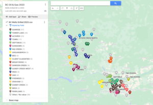
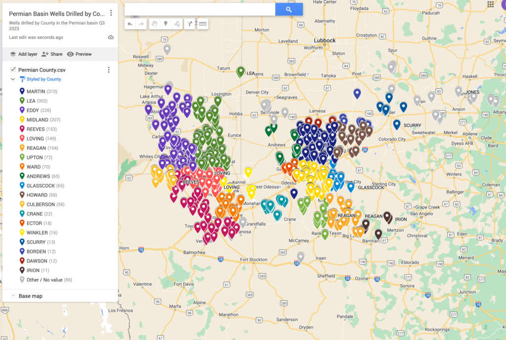
Permian Basin Map – Wells Drilled Q4 2023 by County
The map of the Permian Basin provides a detailed list of drilling activity in Q3 2023 segmented by county.
Permian Basin Operators
Download the complete list of Operators active in the Permian Basin
What is the Delaware Basin?
The Delaware Basin extends from Lea and Eddie counties, NM, in the north down to Pecos County, TX, in the south. The basin’s areal extent covers 13,000 square miles, most of which is sparsely populated. The northern end of the basin lies in New Mexico, giving it exposure to federal land which typically carries a lower royalty rate compared the private leases in Texas and some regions of New Mexico.
What is the Midland Basin?
The Midland Basin spans roughly 14,000 square miles, extending from Lynn County, TX, in the north down to Crockett County, TX. The Midland-Odessa metropolitan area, the most populous in the Permian Basin region, sits atop the core of the Midland Basin and is home to about 340,000 people (ACS, 2018).
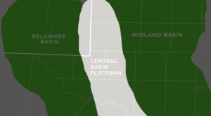
What is the Central Basin Platform?
The Central Basin Platform is in many ways the backbone of the Permian Basin.
While not as aerially extensive as the Midland or Delaware at 6,400 square miles, migrated oil from the basins charged the shallow carbonate reservoirs to create prolific, albeit localized, conventional fields along the Platform’s edges, many of which have transitioned to secondary and tertiary recovery.
Primary target formations include the San Andres, Clear Fork, Tubb, Devonian and Grayburg. Most operators on the Central Basin Platform are small, privately held companies.
What are the Major Permian Basin Formations?
Wolfcamp Shale
The Wolfcamp formations of the Permian Basin represent a time of rapid sediment deposition into the basin when it was at it’s deepest
Spraberry Play of the Midland Basin
The Lower Spraberry
The Lower Spraberry formation is the most targeted of the Spraberry intervals and is characterized by carbonate and shale and layers.
The Middle Spraberry
The Middle Spraberry is an emerging target with similar geologic characteristics to the Lower Spraberry, though is shallower stratigraphically, and is separated from the Lower Spraberry by the Jo Mill. The Upper Spraberry is the least proven.
Bone Spring Play of the Delaware Basin
The Bone Spring Play is a thick package of alternating sands, shales and carbonate intervals in the Delaware Basin, though is primarily targeted in Eddy & Lea counties in New Mexico. The Bone Spring formations overlie the Wolfcamp Shale.
Top Counties in Permian Ranked by Drilling Activity All Time
MIDLAND County – ranks #1 in the state of Texas for BOE produced in the most recent month (Jun 2022). The information below is the summary of oil and gas data that goes back to 1993 and contains information on the 13,795 wells that have been drilled from Jan 1993 to Jun 2022.
Midland County, TX ranks #3 in the Mid Continent (TX, OK,NM,LA) for wells drilled in 2022 with 751 wells drilled.
MARTIN County – Martin County is a county in the U.S. state of Texas. As of the 2010 census, its population was 4,799. Its county seat is Stanton. The county was created in 1876 and organized in 1884. It is named for Wylie Martin, an early settler. Until November 2018, Martin County was one of six entirely dry counties in Texas.
Martin County, TX ranks #3 in the state for BOE produced in the most recent month (Jun 2022). The information below is the summary of oil and gas data that goes back to 1993 and contains information on the 11,322 wells that have been drilled from Jan 1993 to Jun 2022.
Martin County, TX ranks #2 in the Mid Continent (TX, OK,NM,LA) for wells drilled in 2022 with 802 wells drilled.
REEVES County – Reeves County is a county located in the U.S. state of Texas. As of the 2010 census, its population was 13,783. Its county seat and most populous city is Pecos. The county was created in 1883 and organized the next year. It is named for George R. Reeves, a Texas state legislator and colonel in the Confederate Army.
Reeves County, TX ranks #2 in the state for BOE produced in the most recent month (Aug 2022). The information below is the summary of oil and gas data that goes back to 1993 and contains information on the 7,197 wells that have been drilled from Jan 1993 to Aug 2022.
Reeves County, TX ranks #6 in the Mid Continent (TX, OK,NM,LA) for wells drilled in 2022 with 544 wells drilled.
LEA County – Lea County is a county located in the U.S. state of New Mexico. As of the 2010 census, its population was 64,727. Because of oil-lease sales in September 2018, the population was expected to double. Its county seat is Lovington. It is both west and north of the Texas state line.
Lea County, NM ranks #1 in the state for BOE produced in the most recent month (Jul 2022). The information below is the summary of oil and gas data that goes back to 1973 and contains information on the 17,670 wells that have been drilled from Jul 1973 to Jul 2022.
Lea County, NM ranks #1 in the Mid Continent (TX, OK,NM,LA) for wells drilled in 2022 with 1026 wells drilled.
HOWARD County – Howard County is a county located in the U.S. state of Texas. At the 2010 census, its population was 35,012. Its county seat is Big Spring. The county was created in 1876 and organized in 1882. It is named for Volney E. Howard, a U.S. Congressman from Texas.
Howard County, TX ranks #6 in the state for BOE produced in the most recent month (Jun 2022). The information below is the summary of oil and gas data that goes back to 1993 and contains information on the 12,423 wells that have been drilled from Jan 1993 to Jun 2022.
Howard County, TX ranks #5 in the Mid Continent (TX, OK,NM,LA) for wells drilled in 2022 with 574 wells drilled.
EDDY County – Eddy County is a county located in the U.S. state of New Mexico. As of the 2010 census, the population was 53,829. Its county seat and largest city is Carlsbad. The county was created in 1891 and later organized in 1892. It is north of the Texas state line.
Eddy County, NM ranks #2 in the state for BOE produced in the most recent month (Jul 2022). The information below is the summary of oil and gas data that goes back to 1973 and contains information on the 14,166 wells that have been drilled from Jul 1973 to Jul 2022.
Eddy County, NM ranks #4 in the Mid Continent (TX, OK,NM,LA) for wells drilled in 2022 with 674 wells drilled.
LOVING County – Loving County is a county in the U.S. state of Texas. With a population of 169 as of a 2019 estimate by the United States Census Bureau, Loving County is the second-least populous county in the United States after Kalawao County, Hawaii and the least populous of the contiguous United States.
Loving County, TX ranks #4 in the state for BOE produced in the most recent month (Aug 2022). The information below is the summary of oil and gas data that goes back to 1993 and contains information on the 4,801 wells that have been drilled from Jan 1993 to Aug 2022.
Loving County, TX ranks #7 in the Mid Continent (TX, OK,NM,LA) for wells drilled in 2022 with 423 wells drilled.
KARNES County – Karnes County is a county in the U.S. state of Texas. As of the 2010 census, the population was 14,824. Its county seat is Karnes City. The county is named for Henry Karnes, a soldier in the Texas Revolution.
Karnes County, TX ranks #5 in the state for BOE produced in the most recent month (Jun 2022). The information below is the summary of oil and gas data that goes back to 1993 and contains information on the 5,706 wells that have been drilled from Jan 1993 to Jun 2022.
Karnes County, TX ranks #9 in the Mid Continent (TX, OK,NM,LA) for wells drilled in 2022 with 300 wells drilled.
UPTON County – Upton County is a county located on the Edwards Plateau in the U.S. state of Texas. As of the 2010 census, its population was 3,355. Its county seat is Rankin. The county was created in 1887 and later organized in 1910. It is named for two brothers: John C. and William F. Upton, both colonels in the Confederate Army.
Upton County, TX ranks #7 in the state for BOE produced in the most recent month (Jun 2022). The information below is the summary of oil and gas data that goes back to 1993 and contains information on the 12,536 wells that have been drilled from Jan 1993 to Jun 2022.
Upton County, TX ranks #8 in the Mid Continent (TX, OK,NM,LA) for wells drilled in 2022 with 331 wells drilled.
LA SALLE County – La Salle County is a county in Texas. As of the 2010 census, its population was 6,886. Its county seat is Cotulla. The county was created in 1858 and later organized in 1880. It is named for René-Robert Cavelier, Sieur de La Salle, a 17th-century French explorer.
La Salle County, TX ranks #14 in the state for BOE produced in the most recent month (Jun 2022). The information below is the summary of oil and gas data that goes back to 1993 and contains information on the 5,198 wells that have been drilled from Jan 1993 to Jun 2022.
La Salle County, TX ranks #14 in the Mid Continent (TX, OK,NM,LA) for wells drilled in 2022 with 180 wells drilled.